Historic aerial imagery of runoff ponds around the M25 shows they are full of vegetation that has been growing for decades, indicating they have not been maintained by National Highways and are full of potentially hazardous sediment from road runoff.
This is despite guidance recommending they be cleared every 10 to 15 years and National Highways having “a statutory duty to ensure that discharges from its network doesn’t cause pollution for the surrounding environment”, according to the government.
An investigation by NCE using data from a Freedom of Information Act response combined with historical imagery from Google Earth found that many of the 94 ponds around the M25 designed to be regularly emptied have not been maintained for decades.
The data from the FOI response showed that the roads body did not have or would not reveal information relating to the last time 87 of the 94 ponds had been maintained. This means that they are less effective in preventing floods and are likely filling up with hazardous chemicals from road runoff, which could be entering watercourses. Academics and NGOs with experience in this field told NCE that National Highways is likely not investigating them in order to avoid liabilities.
Stormwater Shepherds is a not-for-profit working to improve the health of waterways and its director of operations UK Jo Bradley said: “The runoff ponds that were built at the time that the M25 was built [1960s to 1970s] will be flood storage ponds, built to attenuate flows off the motorway, to manage the peak flow of the runoff during rain events and to manage the volume of runoff entering local streams and rivers.
“However, their role in pollution control was recognised and well understood. The guidance published in 1993 contained design details relating to pollution capture and retention, and described the function and design of oil separators.
“They are important because the construction of a motorway changes the hydraulic behaviour of rainfall across the catchment by introducing a large impermeable area, increasing flood risk, and often draining all the rainfall to one discharge point.
“This would lead to increased flood risk, increased pollution and increased risk of erosion and physical harm to the river unless these ponds/reservoirs were installed.”
In May 2024, Stormwater Shepherds and CIWEM (the Chartered Institution of Water and Environmental Management) published a report which found National Highways and other highways authorities in England have no permits in place for managing the pollutants which are washed off their roads.
The report described road runoff as “hazardous”. It said: “Research by the Environment Agency and [National Highways] has identified a number of pollutants commonly found in highway runoff: copper, zinc, cadmium, fluoranthene, pyrene and polyaromatic hydrocarbons (PAHs).
“These are identified as specific pollutants, priority substances or priority hazardous substances (substances of major concern for European waters due to their toxicity, bio-accumulating properties and/or persistence in the environment that under the Water Framework Directive and its regulations should be progressively reduced or eliminated from surface water).”
Locations of the M25 runoff ponds
Using coordinates provided by National Highways in its FoI response, NCE can reveal the locations of the 94 attenuation ponds aroudn the M25 and through historic aerial imagery the construction dates within certain time period, and maintenance or lack thereof, can be identified.
Below is a map showing the locations of all the ponds listed by National Highways. The full location dataset is at the bottom of this article.
It’s unclear why there is a gap in the north part of the highway and there are some ponds visible on Google Earth around the M25 which look similar to the ones labelled which were not included in the list sent to NCE.
In her analysis of the state of the ponds based on historic satellite imagery, Bradley highlighted the Ciria (Construction Industry Research and Information Association) B14 document: Design of Flood Storage Reservoirs.
The document states: “Sediment removal from within the reservoir or adjacent to inlet zones should be timed so as to cause minimum disturbance to wildlife, and ideally should be undertaken in stages over a few years to allow recolonisation from the undisturbed areas; plants removed during maintenance should be transplanted whenever possible.
“Sediment dredging should take place every 10-15 years.”
Bradley said the Ciria document “was the Bible for designing flood management ponds”.
“That’s what [National Highways] should have been working to; 10 to 15 years maintenance intervals,” she added.
Bradley said features like sediment forebays in or near ponds, and the ponds themselves “would have been constructed and designed with a calculated volume”.
“An engineer would have said ‘Okay, this is the flow rate. This is the residence time that we need behind the sediment forebay, or this is the volume that we need in the sediment forebay’ and they would have worked that out,” she explained.
However, the images of overgrowth on the ponds suggests that these calculations have not been used to inform their monitoring or maintenance requirements.
Beggars Lane pond
The pond at Beggars Lane, which is between junctions 5 and 6 near Westerham in Kent, starts in 1960 as a triangular shaped body but vegetation starts to encroach over the years because of the ingress of sediment from the outfall from the M25.
“That pond is no longer functioning as it was designed to function,” Bradley said.
“Because it had a functional volume that was calculated by the engineer and it no longer functions with that functional value. Now, you could argue that it still did a good job because the vegetation will capture and treat a lot of the pollution and that’s true.
“But that’s not how it was designed to function and nobody’s monitoring it to see if it’s still functioning.
“They’re not being maintained in accordance with their design, [Beggars Lane pond has] not been maintained for years, and they’re supposed to be maintained every 10 to 15 years. And so, although they are still functioning to an extent, there’s no evidence [regarding] whether or not they’re functioning to an acceptable extent. They are not functioning as they were designed to function.
“There’s hundreds and hundreds of tons of [unwanted material] in there that somebody should be taking away and treating, but they’re just not doing it.”

Beggars Lane, December 1960

Beggars Lane, December 1990

Beggars Lane, December 2003

Beggars Lane, September 2018

Beggars Lane, May 2024
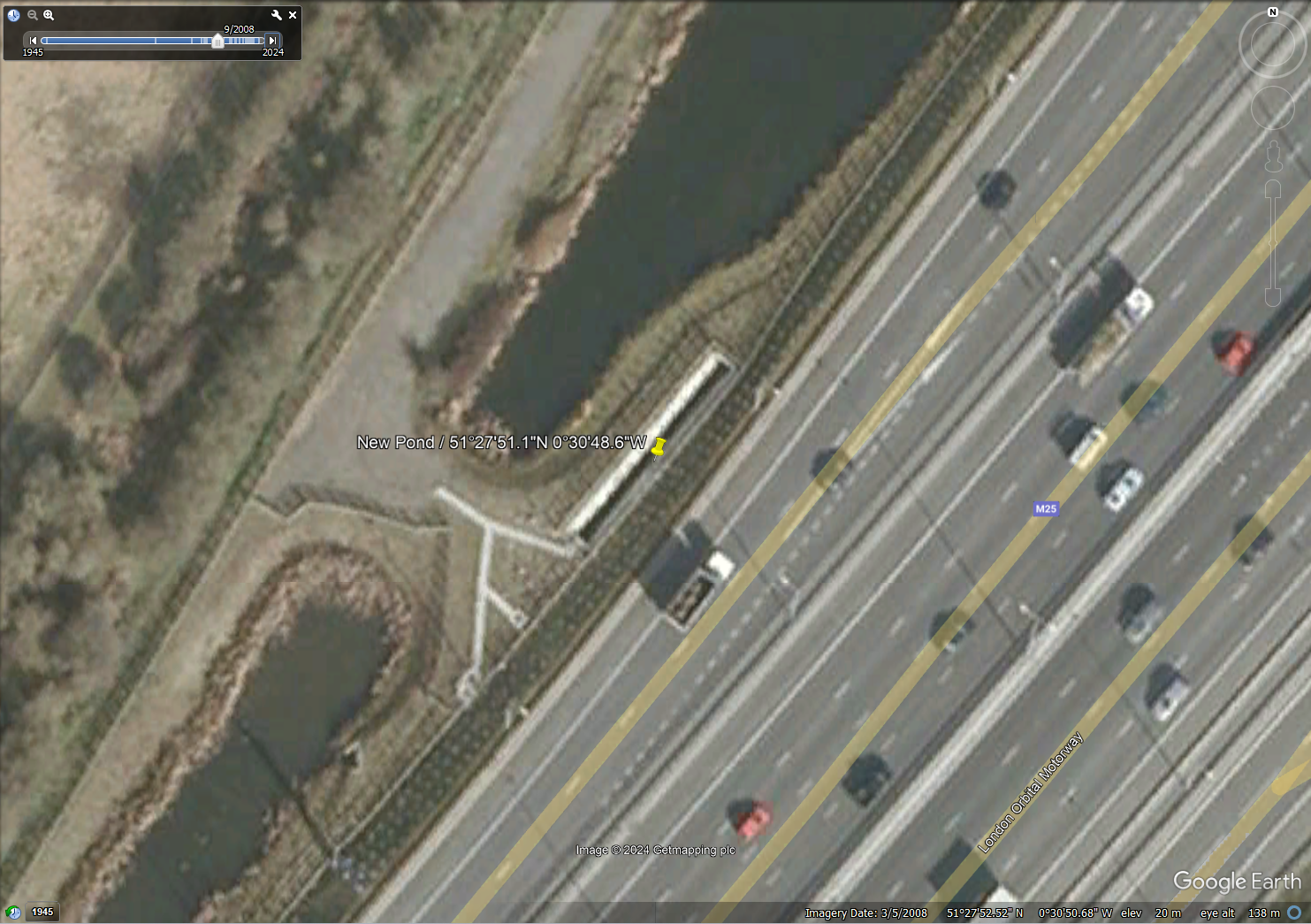
New Pond
New Pond is between junction 13 and 14, near Heathrow Airport.
Judging from the historic imagery, Bradley said the pond “seems to have just completely filled with vegetation”.
There are several different features visible at and near the pond, one of which appears to be a sediment trap, but Bradley said “if that’s supposed to be sediment trap that isn’t working anymore”.
More historic images available on Google Earth of New Pond show activities taking place around the feature, including some clearances, but in the present day, vegetation appears to be thriving, which indicates the presence of large volumes of sediment.
Explaining why some but not all of the vegetation could have been removed, Bradley said: “Sometimes [National Highways commissions] condition surveys, more from an ecological point of view than anything else.
“Sometimes they might go in and go ‘There’s an invasive weed we need to clean the invasive weed’. Or they might go in and say, ‘We need to take this vegetation back to make it a better habitat’.
“The contractor who does the condition survey might come back and say ‘We need to do this piece of work and it’ll cost you £50,000’,” and Bradley said National Highways was likely to commission some work but not others, due to costs.

New Pond, December 1945

New Pond, September 1999

New Pond, December 2002

New Pond, July 2004

New Pond, June 2005

New Pond, December 2006 (1)

New Pond, December 2006 (2 - zoomed in)
New Pond, September 2008

New Pond, June 2013

New Pond, May 2024
Blackdale Fann Pond
The images show the construction and use of Blackdale Fann Pond, which is near Blackdale Farm and sits between junctions 1b and 2 near Dartford, south of the River Thames.
Asked why the pond looks black next to other bodies of water nearby which are a different colour, Bradley said it’s because of “contaminated sediments”.
“It’s just full because the separators haven’t been emptied and they’re huge,” she added. “So they’re going to cost a lot of money to empty and the pond is full of motorway sediment. That’s why it’s that colour.”

Blackdale Fann Pond, December 2003

Blackdale Fann Pond under construction, November 2006

Blackdale Fann Pond, September 2012

Blackdale Fann Pond, May 2024
Response from public bodies
National Highways repeated the response it had provided for the story NCE published earlier in July 2024.
National Highways director of environmental sustainability Stephen Elderkin said: “We are committed to addressing the risk of pollution from road runoff. Our Water Quality Plan 2030 sets out a high-level programme of work to achieve this. We’ve also invested in a programme of research to understand the risk of pollution from microplastics in road runoff.
“High quality road infrastructure can support positive environmental outcomes, and that is at the heart of our work in this area.”
National Highways is a executive non-departmental public body of the Department for Transport.
A Department for Transport spokesperson said National Highways “has a statutory duty to ensure that discharges from its network doesn’t cause pollution for the surrounding environment”.
The spokesperson also pointed to the fact that monitoring of environmental quality standards (EQS) and decisions on permitting are a matter for the Environment Agency.
EQS are limit values set by regulation to manage the concentrations of defined harmful substances, and for water quality, these are set by the Water Framework Directive which is a piece of EU legislation transposed into UK law.
Samples collected from three strategic road network outfalls and six local authority highway outfalls and analysed by CIWEM and Stormwater Shepherds found that discharges from the outfalls “fail the EQS for several PAHs (polyaromatic hydrocarbons)” which “consistently exceeded their maximum allowable concentrations”.
In one instance it was found that PAH concentrations were 730 times higher than the allowed limit.
PAHs are “priority hazardous substances under the Water Framework Directive, which identifies them as substances shown to be of major concern for European waters due to their toxicity, bio-accumulating properties and/or persistence in the environment,” according to the report.
The Environment Agency comes under the remit of the Department for Environment, Farming and Rural Affairs (Defra).
Defra did not respond to a request for comment.
Other ponds showing a lack of vegetation clearance
Below you can find a series of images of other ponds which have clearly not been emptied of sediment because of the presence of vegetation.
The Ciria document and Bradley’s analysis indicate that they are all not being maintained according to the relevant guidance, instead being left to fill up with potentially hazardous waste.
Spur Road Pond
Spur Road Pond is between Junction 4 and the junction with the A21 near the village of Badgers Mount in Kent.

Spur Road Pond, December 1990

Spur Road Pond, May 2024
Godstone Roundabout, Godstone Pond No. 1 and Godstone Pond No. 2
The Godstone ponds are all located on or just east of Junction 6 near the village of Godstone in Surrey.

Godstone Roundabout, Godstone Pond No. 1 and Godstone Pond No. 2, December 2008

Godstone Roundabout, Godstone Pond No. 1 and Godstone Pond No. 2, June 2021
Pavilion Pond and Flooding Pond
They are between Junctions 10 and 11 near the village of Byfleet in Surrey

Pavilion Pond and Flooding Pond, December 1999

Pavilion Pond and Flooding Pond, May 2024
Santerbury Offslip Pond and Santerbury Onslip Pond
These are at Junction 1A south of the Dartford Crossing in Kent.

Santerbury Offslip Pond and Santerbury Onslip Pond, December 1990

Santerbury Offslip Pond and Santerbury Onslip Pond, May 2024
Alderbourne Pond
Alderbourne Pond is near Junction 16 near Pinewood Studios which is in Buckinghamshire.

Alderbourne Pond, September 1999

Alderbourne Pond, May 2024
Interceptor 78/0A and Interceptor 78/0B
The Interceptor 78/0A and Interceptor 78/0B ponds are between junctions 10 and 11 in Surrey.

Interceptor 78/0A and Interceptor 78/0B, December 1999

Interceptor 78/0A and Interceptor 78/0B, May 2024
London Road
London Road pond is near the village of Otford in Kent, between junctions 4 and 5.

London Road, December 1990

London Road, May 2024
Pavillion Pond and Flooding Pond
The ponds are between junctions 10 and 11 in Surrey.
Pavillion Pond and Flooding Pond, December 1999
Pavillion Pond and Flooding Pond, May 2024
Full location data regarding the ponds sent to NCE by National Highways under the Freedom of Information Act:
| Asset name (Pond) | Pond Asset Reference |
Pond Condition Inspection Date |
Easting (region node) |
Northing (region node) |
Last Sediment Removal * Maintenance Year (or not yet required |
| Catherine Borne | TL2101_6154a | 31/03/2023 | 521614.84 | 201542 | 01/03/2023 |
| Warwick Wold Pond | TQ3152_4297b | 22/06/2022 | 531423.71 | 152970.3 | 2022 |
| River Mole East | TQ1458_0438a | 29/06/2022 | 514040.58 | 158380.6 | 2022 |
| Flint Cottages No. 1 | TL0701_7432a | 21/08/2023 | 507746.12 | 201322.1 | 2023 |
| Godstone Roundabout | TQ3552_1777a | 07/06/2023 | 535172.8 | 152771.6 | 2024 |
| River Mole West | TQ1358_8835b | 29/06/2022 | 513880.75 | 158356 | 2024 |
| Stubbs Pond | TQ0798_0395b | 21/08/2023 | 507034.47 | 198950.5 | Due 2023, delayed |
| Pond 1835 | TQ5781_5895a | 01/06/2022 | 557576.08 | 181950.6 | Not yet required |
| Interceptor 78/0B | TQ0463_9216c | 05/02/2023 | 504921.38 | 163163.7 | Not yet required |
| New Pond | TQ0374_3696b | 05/03/2023 | 503359.58 | 174962.4 | Not yet required |
| Santerbury Onslip Pond | TQ5574_8291b | 05/06/2022 | 555826.43 | 174914.7 | Not yet required |
| Pond 1812 | TQ5884_2912a | 05/06/2022 | 558292.52 | 184125.6 | Not yet required |
| Summit Farm 1 | TQ5471_9816b | 05/11/2022 | 554986.37 | 171161.1 | Not yet required |
| Hawley Road Infiltration Pond | TQ5471_9495a | 05/11/2022 | 554939.35 | 171952 | Not yet required |
| IUS Pond 4B | TQ0291_1718a | 08/04/2022 | 502168.37 | 191182.6 | Not yet required |
| IUS Pond 5 | TQ0292_4794a | 08/04/2022 | 502471.77 | 192946.7 | Not yet required |
| IUS Pond 1698 | TQ5494_8504a | 08/07/2023 | 554862.48 | 194036.1 | Not yet required |
| IUS Pond 1683 | TQ5395_8617a | 08/07/2023 | 553860.34 | 195169.3 | Not yet required |
| IUS Pond 1727 | TQ5692_8711a | 08/07/2023 | 556874.76 | 192118.5 | Not yet required |
| IUS Basin 1605 | TQ4799_6768a | 08/07/2023 | 547666.51 | 199689.3 | Not yet required |
| IUS Basin 1609 | TQ4799_9447a | 08/07/2023 | 547953.68 | 199466.3 | Not yet required |
| Pond 1824 | TQ5783_8821a | 08/07/2023 | 557893.51 | 183214.6 | Not yet required |
| IUS Pond 8 | TQ0497_2344a | 08/11/2022 | 504234.46 | 197440.9 | Not yet required |
| IUS Pond 31A | TL2101_7125a | 08/11/2022 | 521711 | 201252.3 | Not yet required |
| IUS Pond 31B | TL2101_6835c | 08/11/2022 | 521682.32 | 201351.2 | Not yet required |
| Black Horse Lane | TL2102_0717a | 08/11/2022 | 521068.88 | 202177.7 | Not yet required |
| London Road | TQ5058_6653b | 13/05/2022 | 550664.16 | 158536.9 | Not yet required |
| IUS Pond 22 (NEW) | TL1402_9246a | 15/08/2022 | 514923.49 | 202466.7 | Not yet required |
| IUS Pond 21 | TL1402_4442a | 15/08/2022 | 514445.27 | 202412.5 | Not yet required |
| IUS Pond 25 - NEW | TL1602_6769a | 15/08/2022 | 516671.39 | 202697.9 | Not yet required |
| Soakaway Six (The Stacks) | TL1103_5112c | 15/08/2022 | 511528.98 | 203130.4 | Not yet required |
| Soakaway Three (The Stacks) | TL1103_7917e | 15/08/2022 | 511793.61 | 203173.1 | Not yet required |
| Soakaway One (The Stacks) | TL1103_8817f | 15/08/2022 | 511889.13 | 203175.9 | Not yet required |
| Woodys Dell | TQ0598_8318a | 16/08/2022 | 505832.75 | 198185.9 | Not yet required |
| Quarry Pond | TQ0799_3017a | 16/08/2022 | 507302.59 | 199175.8 | Not yet required |
| Amersham Road Pond | TQ0187_6253a | 16/08/2022 | 501633.6 | 187529.4 | Not yet required |
| Chevening Lagoon | TQ4856_9453a | 17/06/2022 | 548938.49 | 156534.8 | Not yet required |
| IUS Pond 1791 | TQ5886_7937a | 17/08/2023 | 558785.99 | 186373.5 | Not yet required |
| IUS Pond 1763 | TQ5888_3993a | 18/07/2023 | 558395.28 | 188934.2 | Not yet required |
| IUS Pond 1776 | TQ5887_8666a | 18/07/2023 | 558862.35 | 187665.2 | Not yet required |
| Mill Pond | TQ4655_4759n | 19/05/2023 | 546471.36 | 155589.6 | Not yet required |
| King George Field | TQ5571_4057d | 21/06/2023 | 555403.45 | 171570.9 | Not yet required |
| Summit Farm 2 | TQ5471_8807b | 21/06/2023 | 554880.83 | 171072.6 | Not yet required |
| IUS Pond 16 | TL1002_5286a | 21/08/2023 | 510511.57 | 202857.2 | Not yet required |
| IUS Pond 15 | TL0802_9876a | 21/08/2023 | 508990.72 | 202769.2 | Not yet required |
| Flint Cottages No. 2 | TL0701_7320b | 21/08/2023 | 507731.4 | 201200.4 | Not yet required |
| Brasted Gate | TQ4655_4471a | 22/06/2022 | 546447.5 | 155714 | Not yet required |
| Beggars Lane | TQ4555_3912a | 22/06/2022 | 545392.67 | 155125.8 | Not yet required |
| Santerbury Offslip Pond | TQ5575_8105c | 24/08/2023 | 555814.91 | 175057.8 | Not yet required |
| IUS Pond 3 | TQ0188_5522a | 25/08/2023 | 501554.15 | 188214.9 | Not yet required |
| Blackdale Fann Pond | TQ5572_4245a | 27/05/2022 | 555413.43 | 172452.1 | Not yet required |
| Interceptor 78/0A | TQ0463_8813d | 27/06/2022 | 504879.58 | 163132.8 | Not yet required |
| Interceptor 78/2B | TQ0463_8723b | 27/06/2022 | 504875.81 | 163238.4 | Not yet required |
| Allotment Gardens | TQ0562_1861c | 27/06/2022 | 505180.12 | 162620.4 | Not yet required |
| QE2 Pond | TQ5777_5246d | 29/08/2023 | 557524.91 | 177467 | Not yet required |
| Brook Pond | TQ5782_9295b | 29/08/2023 | 557919.56 | 182953.4 | Not yet required |
| IUS Pond23 | TL1502_2553b | First visit due 2024 | 515261.01 | 202536.8 | Not yet required |
| IUS Pond 27B | TL1803_7719c | First visit due 2024 | 518773.05 | 203191.6 | Not yet required |
| IUS Pond 27A | TL1903_1937a | Unknown | 519193.93 | 203383.1 | Not yet required |
| M25 84/4A | TQ0168_5853a | 05/02/2023 | 501588.4 | 168533.7 | Not yet required. |
| 86/5A | TQ0170_5359a | 05/02/2023 | 501529.67 | 170601.6 | Not yet required. |
| Pavillion Pond | TQ0561_5459b | 05/02/2023 | 505547.66 | 161592.6 | Not yet required. |
| Flooding Pond | TQ0561_5537b | 05/02/2023 | 505553.25 | 161377.6 | Not yet required. |
| Interceptor 76/6A | TQ0561_5393b | 05/02/2023 | 505534.47 | 161926.2 | Not yet required. |
| 66/0 | TQ1358_8529a | 05/02/2023 | 513859.37 | 158294.1 | Not yet required. |
| 86/9A | TQ0171_5106a | 05/03/2023 | 501516.21 | 171061.2 | Not yet required. |
| Godstone Pond No. 2 | TQ3552_3380b | 07/06/2023 | 535335.82 | 152802.5 | Not yet required. |
| Interceptor 85/3A | TQ0169_5440a | 08/04/2022 | 501547.73 | 169405.6 | Not yet required. |
| Spur Road Pond | TQ4962_0492b | 08/11/2023 | 549041.84 | 162922 | Not yet required. |
| Godstone Pond No. 1 | TQ3552_3377b | 13/05/2022 | 535333.63 | 152776.5 | Not yet required. |
| TQ3753_9261a | TQ3753_9261a | 1st visit due 2024 | 537940.67 | 153578.3 | Not yet required. |
| TQ3753_9260a | TQ3753_9260a | 1st visit due 2024 | 537925.09 | 153603.5 | Not yet required. |
| TQ0167_8969b | TQ0167_8969b | 1st visit due 2024 | 501897.89 | 167692.9 | Not yet required. |
| M20 Fast Entry Link | TQ5368_3693b | 21/06/2023 | 553359.97 | 168936.3 | Not yet required. |
| Redhill Bottom | TQ2853_9470b | 22/06/2022 | 528943.91 | 153709 | Not yet required. |
| Gatton Bottom | TQ2753_9268b | 22/06/2022 | 527929 | 153684.8 | Not yet required. |
| Pointers Pond | TQ0859_2920b | 25/08/2023 | 508294.73 | 159206.9 | Not yet required. |
| Costal Pond | TQ2154_3069b | 25/08/2023 | 521302.61 | 154696.7 | Not yet required. |
| Alderbourne Pond | TQ0185_8755a | 25/08/2023 | 501876.78 | 185552.1 | Not yet required. |
| TQ0659_3386a | TQ0659_3386a | 25/08/2023 | 506335.72 | 159861.4 | Not yet required. |
| Swanley Pond 1 | TQ5267_8788b | 27/05/2022 | 552870.25 | 167886.5 | Not yet required. |
| Interceptor 74/4A | TQ0659_1988b | 27/06/2022 | 506195.13 | 159885.7 | Not yet required. |
| Interceptor 65/8A | TQ1458_0432c | 27/06/2022 | 514048.35 | 158322.4 | Not yet required. |
| Interceptor 84/5B | TQ0168_6655a | 28/06/2022 | 501659.51 | 168556 | Not yet required. |
| Interceptor 86/4B | TQ0170_6050a | 28/06/2022 | 501582.3 | 170651.7 | Not yet required. |
| Interceptor 87/4A | TQ0171_6843c | 28/06/2022 | 501687.03 | 171438.7 | Not yet required. |
| 87/0B | TQ0171_5809b | 28/06/2022 | 501587.36 | 171096.3 | Not yet required. |
| West Hall Pond | TQ0560_9411a | 28/06/2022 | 505939.58 | 160119.1 | Not yet required. |
| Leatherhead Lagoon | TQ1658_6939a | 29/06/2022 | 516690.37 | 158398.4 | Not yet required. |
| Leatherhead Lagoon (second | TQ1658_6547b | 29/06/2022 | 516657.06 | 158477.4 | Not yet required. |
| M25 86/3A | TQ0170_5829a | 29/06/2022 | 501580.38 | 170305.6 | Not yet required. |
| Interceptor 73/6B | TQ0659_8261a | 29/06/2022 | 506819.88 | 159610.1 | Not yet required. |
| Muggeridge Wood | TQ1257_7297a | 29/06/2022 | 512720.54 | 157973.1 | Not yet required. |
| Pond 50/5A | TQ2652_7497a | First visit due 2024 | 526738.89 | 152967.9 | Not yet required. |
| *Not all ponds require sediment removal due to the design of upstream silt capture devices. Sediment removal is based on condition inspection results. | |||||
Like what you've read? To receive New Civil Engineer's daily and weekly newsletters click here.


Have your say
or a new account to join the discussion.